Network files
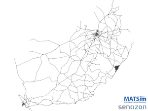
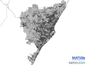
The detailed, cleaned up MATSim network files generated from OpenStreetMap in June 2014. Each area is made up of a coarse national network merged with the local dense network. Consider for example eThekwini in KwaZulu-Natal on the East coast of South Africa.


On the left you can see the coarse network, and on the right the same network zoomed in to eThekwini. The networks have been cleaned up. The projected coordinate reference system is South African Albers Equal Area. In MATSim, it is referred to as "WGS84_SA_Albers".
| File | Modified | |
|---|---|---|
|
File BuffaloCity.xml.gz |
Jun 28, 2014 by Joschka Bischoff | |
|
File CapeTown.xml.gz |
Jun 28, 2014 by Joschka Bischoff | |
|
File eThekwini.xml.gz |
Jun 28, 2014 by Joschka Bischoff | |
|
File Gauteng.xml.gz |
Jun 28, 2014 by Joschka Bischoff | |
|
File Mangaung.xml.gz |
Jun 28, 2014 by Joschka Bischoff | |
|
File Mbombela.xml.gz |
Jun 28, 2014 by Joschka Bischoff | |
| Jun 28, 2014 by Joschka Bischoff | ||
|
File Polokwane.xml.gz |
Jun 28, 2014 by Joschka Bischoff | |
|
File Rustenburg.xml.gz |
Jun 28, 2014 by Joschka Bischoff | |
|
PNG File eThekwini-National.png |
Jun 28, 2014 by Joschka Bischoff | |
|
PNG File eThekwini-Local.png |
Jun 28, 2014 by Joschka Bischoff |